Penobscot and Washington Counties (now Aroostook County), Maine
and
Carleton County (now Madawaska Co.), New Brunswick
The Deane and Kavanagh report is an invaluable source of information on the people who lived on both the north and the south banks of the upper St.John River, as well as in the Aroostook River valley, in 1831, a time when this whole region was disputed territory. Not only does it give the names of heads of households, it also gives where many of them were from, how much land they owned and any improvements on the land, and occasionally other information. This report is therefore an incredibly important source for anyone working on history or genealogy in this region, on both sides of the river.
Because the north bank of the upper St.John River was at that time claimed by the United States, this survey also includes communities that are now in New Brunswick. More information on the border dispute.
In the summer of 1831 the governor of the State of Maine, under direction from the legislature, sent John G. Deane and Edward Kavanagh to survey the Madawaska Settlement, at that time in a territory disputed between the United States and Great Britain (at the time New Brunswick was a British colony). Both Deane and Kavanagh were members of the Maine legislature; Kavanagh in 1831 became a member of the US House of Representatives from Maine.
"There was at that time an understanding between the British and American governments, that, pending the issue of the negotiations for the settlement of the boundary, both parties should refrain from any acts of aggression in the disputed territory. In the early part of the year 1831, the award of the King of the Netherlands was received [he had been commissioned as an arbitrator to decide where the border between the US and the British territories actually ran]. It provided that the River St.John, from the point where it is intersected by the north line from the source of the St. Croix to the mouth of the St. Francis, should form a part of the international boundary.
[By the terms of the treaty of 1783 the north line from the source of the St. Croix--part of the current eastern boundary of Maine-- was to extend to the highlands. But "the decision of the royal arbitrator was that the highlands were to be found in the depths of the St. John River"; that is, instead of making the highlands the boundary, he made the river itself the boundary.]
"The award was accepted by the British but subsequently rejected by the American Senate.
"Edward Kavanagh . . . in 1831 was appointed, with John G. Deane, to visit and report upon the condition of settlement of the 'disputed territory,' on the head waters of the River St. John and its tributaries. This necessitated a long and toilsome journey through wilderness . . ." (Raymond, pp.344-357)
| "Map to illustrate the
Report of Deane and Kavanagh 1831" Raymond,
p.389. The blue traces the route Deane and Kavanagh travelled to get to the St.John River Click on map to see enlarged details 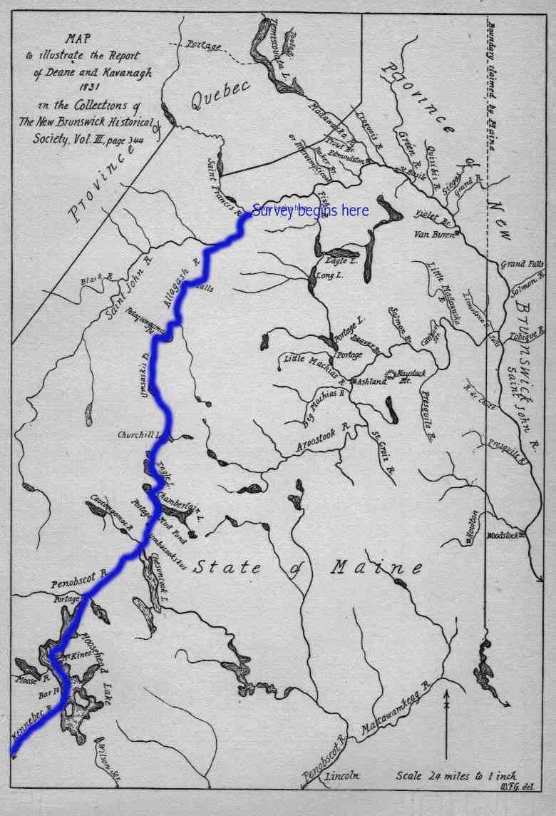 |
The specific instructions that Deane and Kavanagh received from the Governor, Samuel E. Smith:
They received further detailed instructions on how they were to proceed from the State Land Office (the Land Office Instructions to Deane and Kavanagh). |
They arrived at the confluence of the St. Francis and St. John Rivers on July 24, and began their survey.
"They explored both sides of the Saint John river to D'Aigle's Island, below Baker Brook, a distance of fifteen miles. They then confined their attention to what is now the Maine side of the river arriving at Grand Falls on the 3rd of August. In the course of nine days they had proceeded down the river seventy-five miles and gathered data concerning settlers on some 270 locations. On their return up the river to D'Aigle's Island they were employed but five days in investigating the state of settlement, along what is now the New Brunswick side of the river, and gathering data concerning the settlers on some 220 locations. ..."The total number of lots taken possession of is nearly 500; all but about sixty were held by French inhabitants. Of the latter it seems that about 158 are of Acadian origin and 192 of Canadian origin, while about 70 cannot be placed. . . .
"Most of the Canadian founders of Madawaska came from Kamouraska, Temiscouata, L'Islet and a small part of Rimouski County, and chiefly from the following centres: St. André, Rivière-Ouelle and L'Isle Verte. The Acadians who settled at Madawaska came chiefly from the settlements on the lower Saint John a few miles above Fredericton. Others, including the Thibodeaus and Violettes, came from a small French settlement at Hammond River, near the Kennebecasis. Of the Acadian founders of Madawaska the Cormiers, Cyrs, Daigles, and Heberts came from Beaubassin at the head of the Bay of Fundy, the Martins from Port Royal, the Mercures and Therriaults from L'Isle Saint-Jean (or Prince Edward Island), the Violettes from Louisburg and the Mazerolles from Rivière Charlesbourg." Raymond, p.452
After finishing their survey of the St. John River valley, Deane and Kavanagh proceeded to do a similar survey of the Aroostook River valley.
(The information cited here is from "State of the Madawaska and Aroostook Settlements in 1831" by W.O. Raymond in Collections of the New Brunswick Historical Society, no. 9 (1914), pp.344-386.
The full text of Deane and Kavanagh's report is in the same issue of that journal, pp.386-479)
As a sign of appreciation for his work on this survey as well as for his part in incorporating Madawaska, and other work on the border issue, the state legislature later in 1831 made Deane a grant of 1/2 township of land "on the upper waters of the St.John River," although he apparently never made use of the land. Deane died in November 1839. Deane, p.193
Edward Kavanagh was born in Damariscotta Mills, Newcastle, Lincoln County, Maine, on April 27, 1795. "His father, James Kavanagh, came from Wexford County in Ireland, to Boston in 1780. He married Sarah Jackson of Boston. Removing to Damariscotta Mills, he engaged in lumbering and shipbuilding, and accumulated some property." His son Edward attended Montreal Seminary (the Jesuit College) in Montreal, Canada, and Georgetown College, Georgetown, D.C.; was graduated from St. Mary’s College, Baltimore, Md., in 1813; studied law; was admitted to the bar and commenced practice in Damariscotta, Maine.
A Democrat, he was a member of the Maine State house of representatives from
1826-1828, and secretary of the State senate in 1830. He was elected in 1830
and 1832 as U.S. Representative from Maine's 3rd District to the Twenty-second
and Twenty-third United States Congresses (March 4, 1831-March 3, 1835). He
ran for relection in 1834 but was defeated. He was appointed U.S. Chargé
d'Affaires to Portugal on March 3, 1835, and served until his resignation in
June 1841. He was one of the members of the joint commission on the northeastern
boundary in 1842. He was a member of the Maine State senate in 1842 and 1843
and served as president of that body. He became Governor of Maine upon the resignation
of Governor Fairfield on March 7, 1843, and served until the end of the term
in 1844. He died in Newcastle, Maine, on January 22, 1844, and is buried at
St. Patrick's Catholic Cemetery, Damariscotta Mills, Maine.
Sources: Raymond, pp.384-385,
http://politicalgraveyard.com/bio/kaufmann-keast.html
http://bioguide.congress.gov/scripts/biodisplay.pl?index=K000022
John G. Deane was born in Raynham, Massachusetts, March 27, 1785, the son of Joseph and Mary (Gilmore) Deane. He graduated Brown University in 1806; read law in Taunton, Massachusetts, with Judge Seth Padelford, and settled in Ellsworth, Maine, about 1810. He married Rebecca Padelford (youngest daughter of Judge Padelford and Rebecca Dennis, his wife), on September 13, 1810. He was admitted to practice as an attorney in the Court of Common Pleas in Hancock County in 1810. He was active in Federalist politics, and was a representative from Elsworth to the Maine legislature from 1825-1828, and in 1831. During this time he was very involved in what was then referred to as the "Northeast Boundary Question"; indeed, in 1828 he and Charles S. Davies explored the "disputed territory." He died November 10, 1839 at Cherryfield, Maine. He was buried in the Western Cemetery in Portland, Maine. Source: Deane
The survey's purpose was to count the inhabitants of Madawaska settlements, but also to gather claims to land these people held, and how they had obtained the land. Thus the survey is very interesting not only because it is a virtual head of household census, as well as a survey of land holdings, but it also gives an account of the state of the land, improvements, etc. In addition, the survey provides information on the origins of the settlers.
Those that are listed as from Canada were French from Quebec; those listed as from Madawaska were almost all Acadians, that is people who themselves or whose parents had been expelled from Acadia--now Nova Scotia and New Brunswick--by the British. The original expulsion took place in 1755; some of these Acadians settled lower down on the St. John River in what is today New Brunswick. At the close of the American Revolution, however, the British government was bound to provide those who remained loyal to the Crown and who now were forced to leave the former American colonies with land. Many of them received land along the St.John, where the Acadians had settled. So between 1783 and 1785 many of the Acadians were once again uprooted, and moved further up the river to what became known as the Madawaska territory. Those people who are listed as from Acadia or from Madawaska are Acadian French. Others of the settlers were Irish or Scottish, some were from New Brunswick, a few from downstate Maine.
In the report land holdings are measured in terms of "rods front". 1 rod = 16-1/2 feet, or 5-1/2 yards; 320 rods = 1 mile. A "rod front" is the width of the land holding that fronts on the river bank.
If you've looked at the transcription of the Deane and Kavanagh report you probably have seen that the way they visited land sites was not necessarily in geographical order. Site visitor Rick Fournier has compiled spreadsheets that make the Deane and Kavanagh report more searchable and accessible, in particular by listing the lots and owners in order of where they were located. He's also made alphabetical lists of the owners. Here's his explanation:
When I initially used your file to index a name it just sent me to the general file on the North or South side of the St John River. That was not satisfying to me as I needed to immediately find a lot location and its owner. So I entered the info into a spreadsheet.
First I numbered the lots from West to East on each side of the SJR. This was easy for the South or American side since Deane and Kavanagh fairly well kept to a consecutive order on that side.
However, numbering the North or Canadian side was not so easy. At one point Deane and Kavanagh went to Grand Falls on that side and came back up the river, which was confusing to find out where you were. I reversed the order of those lots and reconnected them from I believe the Quisibis River on down. That way, the order from West to East was adjusted on the North Side.
Once I had each lot numbered (North of South of the SJR) I could Index the names with each lot.
While working with the file I wanted to find out who resided on each side and added a Resident note beside the name. In some cases I could not find out where they lived and left it blank.
I tried to highlight in red all geographical locations to pinpoint the lot.
I also wanted to list who owned the lot before by sale or deed transfer. I have these names indexed. This gave me an additional list of names that did not seem to be in the different census.
Deane and Kavanagh placed some additional notes associated with each lot. I indexed these with the lot number.
As Rick noted, the name index I compiled only takes you to a page with either all of the land on the North or South shore of the St John. His spreadsheet allows you to search for names alphabetically.
Below is a link to a webpage that includes nine sheets - you'll see the tabs at the bottom of the screen. Here is a description of each sheet, starting with the abbreviation that shows up in the tab:
Spreadsheets of Deane and Kavanagh report
I want to thank Rick for taking the time and effort to compile the spreadsheet and for being generous enough to share it with the visitors to this website. Thanks Rick!
Go to Deane and Kavanagh's survey of the South
Bank of the St. John River
Go to Deane and Kavanagh's survey of the North
Bank of the St. John River
Go to Deane and Kavanagh's observations about the
Madawaska Settlements
Return to the Upper St.John Valley Communities page
Terms of use
Last revised 19 March 2021
© 2003-2021 C. Gagnon